A
polygonal mesh is a group of geometric component that when placed together make
up a shape of an object. Each mesh is made up of vertices, edges and faces. The
shape changes as editing is done to the components. Meshes vary in size. The
shape of the object varies from the exact positioning of the vertices, edges
and faces. The faces are in the shape of triangles, quadrilaterals, and other
polygons. Computer graphics and animation use mesh based graphics.
Polygonal mesh graphics are used to
visualize data in many of the sciences. The high quality of lighting and
shading of 3D mesh graphics meet scientists’ need to show scientific
visualization of their experiments. One area that makes use of mesh-based
graphics is astronomy. The astronomical data is visualized by mesh
based-graphics for research and education. Mesh graphics also help with
outreach programs to help educate the lay public about
astronomical advances and findings.
Mesh-based graphics is also used in
medical science. It is used in the modeling of body muscles and tissues
including the brain and the knee. It helps doctors see these body parts more defined
structurally as they prepare for surgery and during the virtual surgery itself.
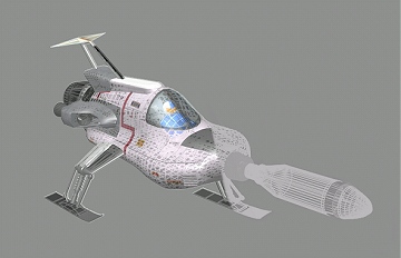
Another area of use is haptics. Haptics technology (using input/ output device
like a joy stick) and mesh-based visual displays work together to train people
in hand-eye coordination. Space ship maneuvers and surgery are two important
uses for this training.

Developing software programs for
these meshes is in high demand. Software
programs, like Blender, are chosen for their versatility and flexibility in
handling different types of visualization ideas and concepts. The industry is
flourishing with the movie, television and virtual reality
gaming industry’s extensive use of these 3D meshes.
Animation which is widespread use in these industries uses mesh graphics in its
development of complex structures used in shows and games. Mesh based graphics
is also used in the animation of maps for geographic information systems.
Topographic maps show the shape of land surfaces by using mesh based graphics.

No comments:
Post a Comment